


This narrow, twisting road runs for 12kms between the town of Dingle on the south and Kilmore Cross on the north of the peninsula, where roads fork to Cloghane/Brandon or Castlegregory. The views from the road are breath-taking, with a glaciated landscape of mountains, corrie lakes and a broad sweeping valley spread out below.
At the steepest part, the road weaves its way around, sharp cliff faces and passes high corrie lakes. There are some very narrow sections where there would only be room for one car so allow cars to come up before you descend. There are lots of opportunities to stop or give way to other traffic at wider sections along the road. Larger vehicles or any vehicle over two tonnes in weight are prohibited from using the Conor Pass to avoid difficulties in passing other vehicles.
There are two main viewing stops, one at Peddlar’s Lake on the north side and the other at the top. From the scenic car park at the summit there are fantastic views north and south of the Dingle Peninsula along the Wild Atlantic Way and one a good day you might see as far as the Cliffs in Co. Clare or the Aran Islands, off Co. Galway
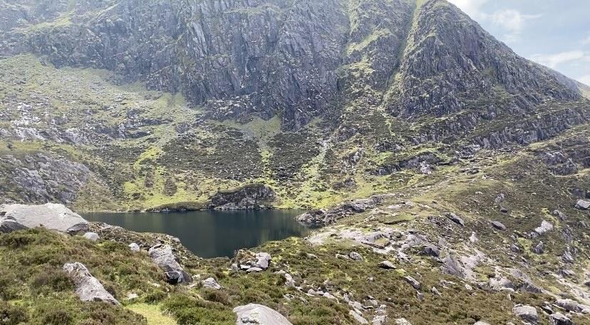
Pedlar’s Lake – Lough Doon Corrie Lake
Lough Doon (locally known as Pedlar’s Lake) is a glacial corrie lake that sits above the road on the north side of the Conor Pass. Beneath the lake is the Conor Pass waterfall with a small car park and viewing area. The lake is accessed by climbing up a small rock path above the car park. From this vantage point you can view the glaciated mountain scenery of the Dingle Peninsula.
Picture 1 Pedlars Lake
 Conor Pass Car Park
Viewing point on the Wild Atlantic Way Route.
When leaving Dingle town, you have two options – you can take the N86 road to Lispole or you can take the Conor Pass. The drive to the top of the pass is twisty but the road is wide, and the drive should take no longer that 10 minutes to the small car park where you can stop and admire the dramatic view. This is considered one of the iconic viewing points of the Wild Atlantic Way. From here looking south you can see across Dingle Bay to the Iveragh peninsula, Ring of Kerry and out to sea the Skellig Rocks. Looking to the North is Kerry Head and Loop Head Co.Clare. Occasionally in very clear weather it is possible to see the Aran Islands off Co.Galway.
Advice for Driving the Conor Pass – An Chonair
The Conor Pass is a mountain pass with length (max. 7.2m) and weight restrictions (max 2 tonnes). Vehicles greater than 2 tonnes in weight are not permitted to travel north-east of the car park at the summit of the Conor Pass. Vehicles such as coaches, caravans, camper vans and trucks cannot use the pass as they will not get through.
The first 2 km descent of the Conor Pass towards Cloghane Brandon, Castlegregory and Camp is narrow with several lay-bys to allow traffic to pass. Please yield beside lay-bys to allow any oncoming vehicles to pass with ease.
The final 2 km ascent of the Conor Pass from Cloghane Brandon, Castlegregory and Camp is narrow with several lay-bys to allow traffic to pass. Signage is in place to advise of their location. Please pull in when you see on coming vehicles.
The Conor Pass is not suitable for HGVs. Whilst vehicles can get to the summit of the Conor Pass from Dingle Town, the road from the Summit to Cloghane Brandon, Castlegregory and Camp is not accessible to any vehicle over 2 tonnes.
Use fog lights when driving in poor visibility and watch out for the signs that indicate how far motorists must travel to the next passing bay.
Download a map of the drive here…..